What is Chandrashila Peak and Why is it Famous?
Chandrashila Peak — meaning "Moon Rock" in Sanskrit — stands at 4,130 metres above sea level in the Chopta region of Rudraprayag district, Uttarakhand. It is the highest accessible summit in the Tungnath–Chopta trekking zone and offers one of the most spectacular 360° Himalayan panoramas in all of Uttarakhand. On a clear morning, trekkers on the Chandrashila summit can see Chaukhamba (7,138m), Kedarnath (6,940m), Nanda Devi (7,816m — India's highest peak entirely within Indian territory), Trishul (7,120m), Bandarpunch (6,316m), and on the clearest days, the faint outline of Kamet (7,756m).
According to Hindu tradition, Chandrashila is the spot where Lord Chandra (the moon god) performed tapasya (meditation) to atone for a celestial misdeed. The name Chandrashila — "Moon's Rock" — reflects this legend. The peak is considered sacred in the same tradition as the surrounding Panch Kedar temples, and many pilgrims visiting Tungnath Temple below make the additional effort to reach Chandrashila to complete their pilgrimage with the panoramic darshan of the Himalayas.
Chandrashila is reached by extending the popular Tungnath Temple trek by 1.5km beyond the temple. The combined route — 3.5km from Chopta to Tungnath, then 1.5km from Tungnath to Chandrashila — gives a total 5km one-way trek from Chopta base, with an altitude gain of approximately 1,450 metres. It is one of the most rewarding high-altitude day treks in Uttarakhand and is firmly established on the bucket list of Himalayan trekkers across India.
Chandrashila Peak Highlights
Chandrashila Trek Route — Complete Guide
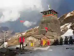
The Chandrashila trek starts at Chopta meadow base (2,680m) and ascends 1,450 metres over 5km to the summit at 4,130m. The trail is divided into two distinct sections — Chopta to Tungnath, and Tungnath to Chandrashila. Allow 4–5 hours for ascent and 2.5–3 hours descent. Start early — by 6–7 AM — to reach the summit before clouds roll in after midday.
Trek Route Breakdown
Parking area, tea shops, and basic accommodation at Chopta. Trek begins here. Pony rides available up to Tungnath Temple (₹700–₹1,000 one way) but NOT to Chandrashila — the final 1.5km is hiking only.
The first section passes through rhododendron and buransh forest (spectacular in May–June bloom) before breaking out into open alpine meadow. The trail is stone-paved in parts and gentle for the first 2km. Steeper and rockier in the last 1.5km before the temple. Allow 2–3 hours for this section.
The world's highest Shiva temple. Rest here, take darshan, have tea from the small stalls near the temple. Many trekkers turn back here — but the Chandrashila summit is just 1.5km further and is absolutely worth the extra effort. Allow 30 minutes rest before continuing.
This section is steeper and more exposed — the trail climbs through open rocky terrain above the tree line. The gradient is significantly more challenging than the Chopta–Tungnath section. There are no tea stalls or shelter above Tungnath. Allow 1.5–2 hours for this section. In winter, this section may require snow-walking skills.
A small temple and flagmast mark the summit. The panoramic view on a clear day is extraordinary — Chaukhamba, Kedarnath, Nanda Devi, Trishul, Bandarpunch, and the Gangotri range all visible simultaneously. This is one of the finest summit panoramas achievable without technical climbing in Uttarakhand. Spend 30–60 minutes here before descending.
What You See from Chandrashila Summit
The 360° view from Chandrashila is the reason thousands of trekkers make the extra effort beyond Tungnath. On a clear day — most likely in May–June or September–October — here is what is visible:
Best Time to Trek Chandrashila Peak
The Chandrashila trek season runs May to November. Below Tungnath Temple (3,680m), the trail is part of the same Chopta ecosystem. The best windows are:
Rhododendron bloom on the trail. Good pre-monsoon visibility. Moderate temperatures at summit (0–8°C). Busiest season — start by 6 AM to avoid afternoon crowds. Fresh snow on peaks from winter adds to the panorama.
Post-monsoon clarity — the sharpest mountain views of the year. Skies crystal-clear, fresh snow on Chaukhamba and Kedarnath. Fewer crowds than May–June. Temperature at summit 0–5°C. Best for photography.
Monsoon season. Trail above Tungnath is slippery rock and wet grass — risk of falls above 3,680m. Views blocked by cloud and mist. Lightning risk on exposed summit. Not recommended for Chandrashila — only Tungnath at most.
First heavy snowfall of the season. The summit section (Tungnath–Chandrashila) may have ice and snow on the trail — micro-spikes/crampons required. Extraordinary snow landscape. Very cold (−10 to 0°C). Full winter gear essential. For experienced trekkers only.
How to Reach Chandrashila Peak
Chandrashila Peak is reached entirely on foot — the road head is Chopta village (2,680m), from where the 5km trek begins. Chopta is accessible by road:
Delhi → Haridwar → Rishikesh → Devprayag → Rudraprayag → Ukhimath → Chopta. Best done overnight with a halt in Rishikesh or Devprayag. Start trek next morning after reaching Chopta by dawn.
Rishikesh → Devprayag → Rudraprayag → Ukhimath → Chopta. Start from Rishikesh by 4–5 AM to reach Chopta by 11 AM–noon and complete the Chandrashila summit the same day, reaching back by 5–6 PM.
Fly into Jolly Grant Airport. Direct flights from Delhi (40 min), Mumbai, Bengaluru. Hire a cab from the airport to Chopta — approximately 7–8 hours via Rishikesh and Rudraprayag.
Nearest railway stations are Haridwar (240km) and Rishikesh (220km). Multiple trains from Delhi daily. Book a private cab onwards to Chopta (7 hours). GMOU buses run to Ukhimath — share jeep from Ukhimath to Chopta (20km).
Essential Tips for Chandrashila Summit Trek
- Start by 6–7 AM from Chopta — aim to reach Chandrashila summit by 10–11 AM before clouds and mist roll in from the valley. Clear skies are almost always a morning phenomenon at 4,000m+.
- Acclimatize at Chopta overnight — if you are driving from the plains, spend the night at Chopta (2,680m) before the summit attempt. Do not rush the Chandrashila section on day one after driving from Delhi or Rishikesh.
- Carry full warm gear even in summer — the Chandrashila summit is 450m above Tungnath and wind-chill at 4,130m is severe year-round. Fleece, windproof jacket, gloves, and warm hat are essential even in May–June.
- Wear proper trekking boots — the Tungnath–Chandrashila section is steep, rocky, and exposed. Sandals, sneakers, or casual shoes are genuinely dangerous on this section. Ankle-support boots are required.
- No facilities above Tungnath — carry sufficient water (1.5–2 litres), snacks, energy bars, and first-aid for the Chandrashila section. There are no tea stalls, shops, or shelter between Tungnath (3,680m) and the summit (4,130m).
- Altitude sickness at 4,130m — the Chandrashila summit is above the altitude where AMS (Acute Mountain Sickness) can affect even fit trekkers. Symptoms: severe headache, vomiting, confusion, loss of coordination. Descend immediately if these appear. Do not ignore symptoms.
- In November/winter — micro-spikes required — the Tungnath–Chandrashila section becomes icy in November. Without traction devices on steep ice, a fall is possible. Carry micro-spikes or crampons if trekking after October end.
- No garbage on the summit — Chandrashila is a sacred and ecologically sensitive zone. All waste must be carried down. Plastic bags are banned in the Chopta–Tungnath area.